
When I briefly started getting back into running after having a stoma in 2019 I was keen to set myself a challenge so whilst sat at the bar in Tiny Rebel in Newport in May 2019 I wondered how long the border around Newport was so fired up the OS Maps app and plotted a route.
Surprisingly there are enough public footpaths to stay fairly close to the border and the total distance was somewhere between 71-72 miles. That sounded like something I could set as a target for myself and had the aim of attempting it in 2020. Things didn’t go too well health-wise and I wasn’t going to be able to attempt it but now that I’m back to normal I’ve set myself the challenge of completing it this year.
This was going to be my biggest challenge to date and the toughest. The furthest I’d run to date was 50 miles and I had some experience of running ultramarathons so was (quietly) confident that it could be something that I’d be able to conquer.
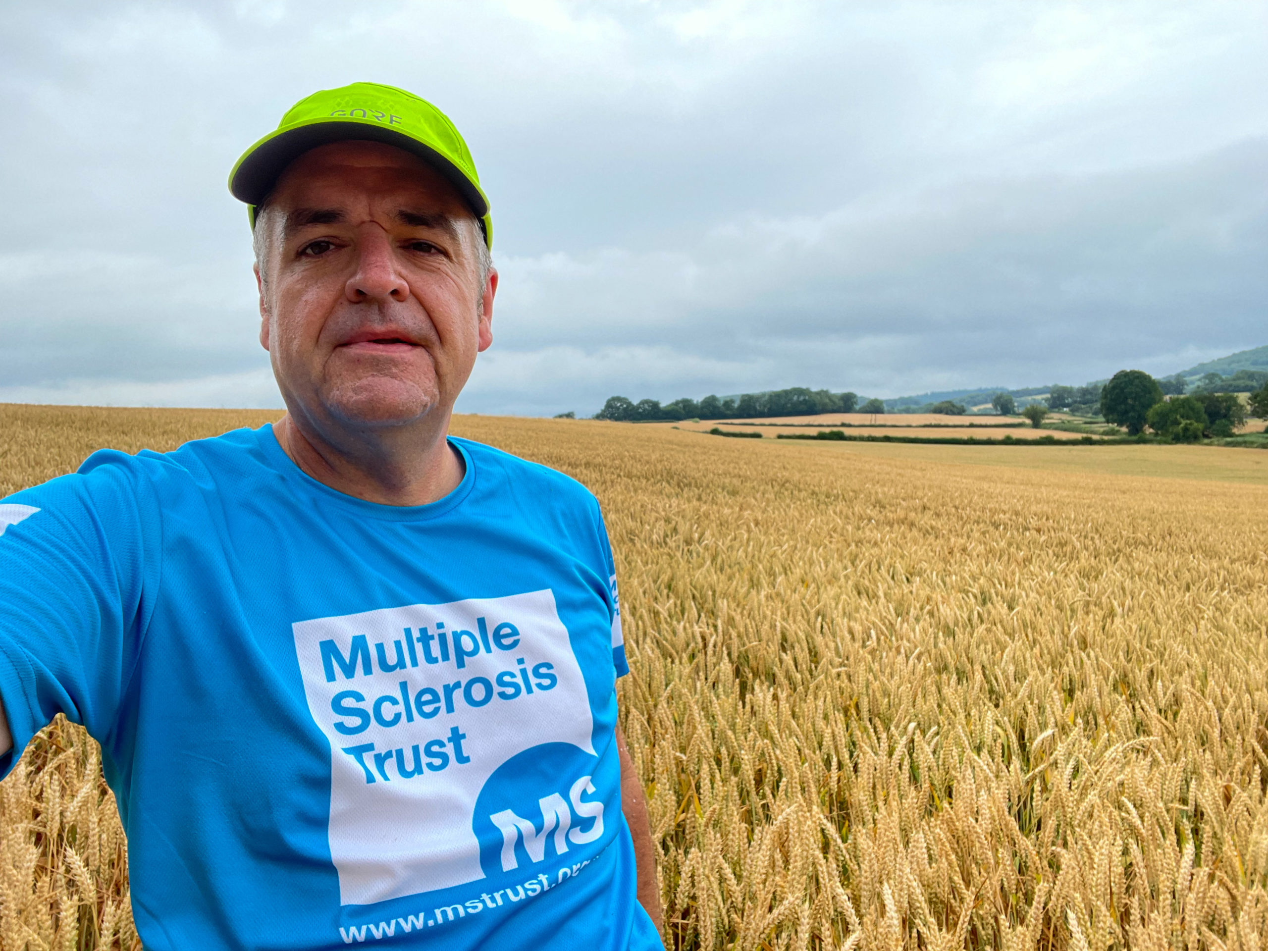
As added motivation I’d decided to raise money for the MS Trust. My brother was diagnosed with Multiple Sclerosis in June 2019 although symptoms started appear as far back as 2011. He experiences a mix of symptoms including fatigue, foot drop meaning that he sometimes has to walk with a stick and would have the occasional unscheduled trip to the floor.
There’s also the mental distress that comes with having such a condition and this is something that I can relate being someone with a stoma and Crohn’s Disease.
By raising money for the MS Trust they will be able to fund specialist nurses, support those with MS and being a voice for those with the condition.
Training
Sitting in between a 100k and a 100-miler, there wouldn’t be a training plan specifically for the distance I was running so decided that the 100k would be more suitable as it was just a little bit more than 100k but the 100 mile plan had a lot longer runs. The plan fitted perfectly for me with runs on Tuesday to Thursday, a long run on a Saturday (which I much prefer) and a slightly shorter longer run on a Sunday.
In the past I would have run before work or during my lunch break and showered in the office but since moving to a new location without a shower I opted to run around 4am which would give me enough time to get in a decent run, perform a colostomy irrigation and then head to work. It would also mean that on challenge day, having an early start would not be a shock to the system.
Strangely, I became used to getting up early and to quote ultrarunner Damian Hall
there’s something deliciously secretive about going out before everyone else is up
Damian Hall
That quote is so true. Getting up that early meant that I got to experience so many colourful skies just before sunrise.
The longer Saturday runs quickly became known as my running adventures and I was plotting routes across South Wales and the West Country. They were my highlight of my week and sometimes I didn’t know where I was heading until the Saturday morning when I was plotting a route on the OS Maps app. And then the running adventures themselves could feature so many different things including wildlife, stunning vistas, historical buildings and interesting curiosities.
With a 20 week training plan I was fortunate enough that I only missed three runs – one due to a bit of a dodgy knee after tripping whilst fossil hunting in Llantwit Major and two longer mid-week runs when I was bed-ridden with a virus. Other than those days, everything went extremely well.
The Big Day
The alarm was set for 02:10am and I was up like a lark when it went off. Breakfast consisted of 3 Weetabix, 2 crumpets and honey, a Precision hydration drink and a Monster Coffee on the way. The big day was here and I was as ready as I’d ever be.
Transporter Bridge to Goldcliff
Distance: 8.2 Miles
Terrain: Predominantly trail through the wetlands, along part of the Wales Coast Path and a small bit of road.
Notable Features: The wetlands and a lighthouse.
How the Section Went
I had been monitoring the weather for the previous 2 weeks and whilst there was a very good chance that there would be rain on the day (and possibly thunderstorms), it was forever changing. When I woke up around 2am it wasn’t raining but by the time I’d reached the start it had started to drizzle. It wasn’t going to be cold so I decided to not wear a jacket and change my wet t-shirt at aid stops.
Two Parc Bryn Bach Running Club members joined me for the first leg and whilst I was familiar with the path leading from the Transporter Bridge I didn’t factor in the fact that at this time of year the vegetation will have grown considerably, including brambles. My support runners were probably expecting a nice and easy run to start with and whilst there was a brief reprieve with a bit of tarmac and more established trails navigating through dark fields featuring reflective eyes of the sheep was interesting.
We managed to make the fields to the Newport Wetlands Nature Reserve where it was much easier to follow. The rain was starting to get heavier at times and in anticipation of wet conditions I had decided at the last minute to wear a pair of waterproof socks that I had bought a few years ago but not worn a long for a long time. When I had worn them on a long Lake District run they worked well but this time they had accumulated a lot of water and one of my toes was starting to hurt.
I continued until the first aid stop and changed to a pair of DryMax socks but the skin on one of my toes had been scraped off. I was kicking myself for making a basic error and not following the golden rule of not trying something different on race day. I was hoping that this wouldn’t cause further issues further into the run.


Goldcliff to Llandevenny
Distance: 9 Miles
Terrain: A good few miles along the Wales Coast Path with some overgrown sections along the way. Leaving the path it switches to road and gravel to Llandevenny.
Notable Features: Scenic coast path (when the weather’s nice), thunder and lightning, and a stinky water treatment works.
How the Section Went
Leaving Goldcliff one of my support runners continued a little way further until the Sea Wall where I would join the coast for the 4.5 mile section to the county border. As soon as I climbed the steps at the Sea Wall join the path a flash of lightning signalling the start of those thunderstorms that were forecast. Being a coastal path the wind had picked up, the rain was coming down hard and the flashes of lightning and rumbles of thunder were becoming frequent. At times the storms were directly above and fortunately there weren’t any trees around!
I knew when I was close to the point where I would be turning off the Wales Coast Path due to the smell in the air. There’s a water treatment plant at the border and the smell is absolutely disgusting. I had experienced the smell a few weeks prior on a recce run but this wasn’t a smell that you’d get used to.
After nearly 14 miles of mainly trail it was time to have a a couple of miles of tarmac on the way to Llandevenny. The thunder and lightning was continuing but thankfully the rain had stopped. Nearing Llandevenny I had the option of taking the easy route along tarmac or following the border through some fields. The plan was to stay as close to the border as possible so went through the fields. The area is so small I didn’t bother checking it out before the run so it was new to me but I still managed to get a little lost trying to navigate through there. It was at this point I en-cow-ntered my first cows!


Llandevenny to Penhow
Distance: 3.7 Miles
Terrain: Some road through Magor and heading north turning off road for a couple of miles and then rejoining tarmac at Penhow.
Notable Features: Penhow Castle and some pretty nice scenery (when the weather’s nice).
How the Section Went
My original route had been plotted along the busy A4810 and whilst it was only a short section, I didn’t fancy running alongside lorries so instead headed beneath the road and into Magor. It was only a short detour and about the same distance but was safer. It was then along some country lanes to a point where I headed off road again and takes you past Penhow Castle. I had a little bit of trouble finding the correct path at this point so a few back and forths through a farm until I managed to find it. It was then onto the Rock and Fountain pub for the first bag change of the day.
I had irrigated the night before so I was pretty empty but hours of sweat doesn’t mix with the glue used to affix the colostomy bag to your skin so starts to get gooey and stretching around the hole. When this starts to happen you need to change it before it comes off.


Penhow to Cadira Beeches
Distance: 4.5 Miles
Terrain: A small amount of trail but largely tarmac all the way to Cadira Beeches.
Notable Features: A biiiiig hill up to Cadira Beeches.
How the Section Went
After running along the A48 for a short distance it was off road towards Llanvair Discoed. I encountered a few more exotic animals (alpacas and a Vietnamese Pot Bellied pig) but they were too far away for selfies with them!
The path I needed had disappeared due to a barley field being in the way so I tried as best as I could to navigate around the edge but wasn’t straightforward and eventually I had to make my own path across to the stile. This along with getting a little lost in the next couple of fields added some extra distance.
I managed to get back on track and rejoined tarmac at Llanvair Discoed for the climb up to Cadira Beeches. The first part of this section was runnable but eventually when I had reached Wentwood Reservoir it was best to walk the rest of the way the Cadira Beeches aid station. I was still feeling pretty good and by the time I reached the aid station I had accumulated an additional mile so was at just over 26 miles.


Cadira Beeches to Caerleon Bridge
Distance: 7.8 Miles
Terrain: Fire trail through Wentwood followed by a long tarmac road to Caerleon.
Notable Features: Wentwood ancient woodland.
How the Section Went
The plan was to follow the border which ran along a fire trail but along the way I deviated to a path further over the border which certainly wasn’t a fire trail! At first the path was just a little muddy but then got considerably worse with water covering the entire path for a few hundred metres. Fortunately I was able to skirt around it so didn’t get wet or muddy but it did slow down progress. The path eventually converged with the path that I needed and then it was time to descend. The path down was rocky at first, then overgrown, then full of thistles, then long grass. All of those things combined didn’t do my legs any favours particularly the quads.
When I finally reached tarmac it I decided that it was time for some music. On long runs I tend to hold off as long as possible to start listening to music so that I appreciate when it’s needed. The road into Caerleon is around 4.5 miles but seems a lot longer so it was a relief when I discovered that one of the runners I was due to meet at Caerleon was running towards me and would meet me halfway. Finally after around 23 miles I’d have someone to run with again.


Caerleon Bridge to Rougemont
Distance: 6.2 Miles
Terrain: Tarmac to a trail section near Ponthir then tarmac through to Rougemont.
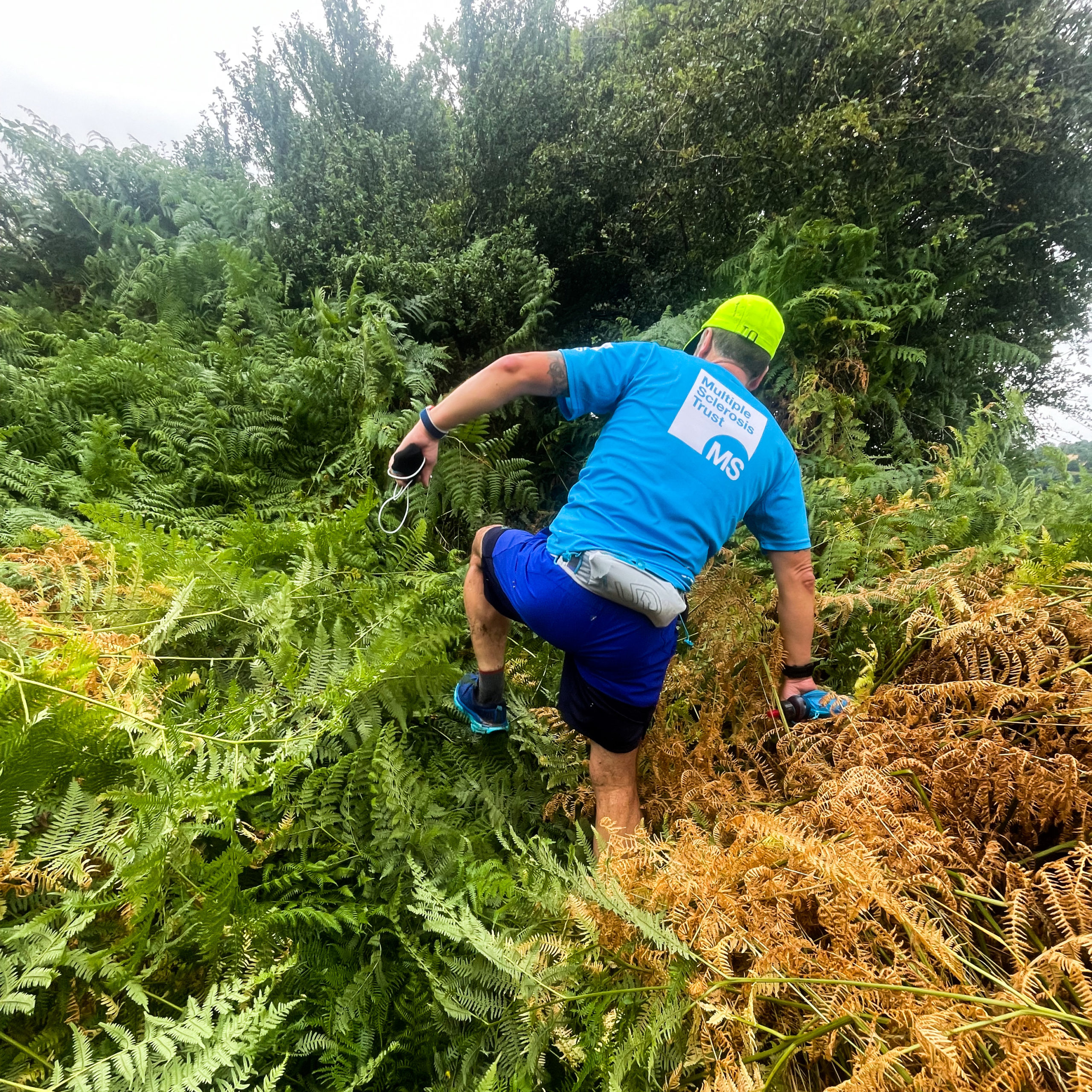
Notable Features: Caerleon Bridge, the path of doom (aka bramble boulevard) and a water treatment works.
How the Section Went
I’ve probably run along 90% of the route at some point over the years so come race day I thought I’d be prepared for most of it. One thing I didn’t take into account was the time of year and in the summer the vegetation has a bit of a growth spurt which can make paths difficult to get through.
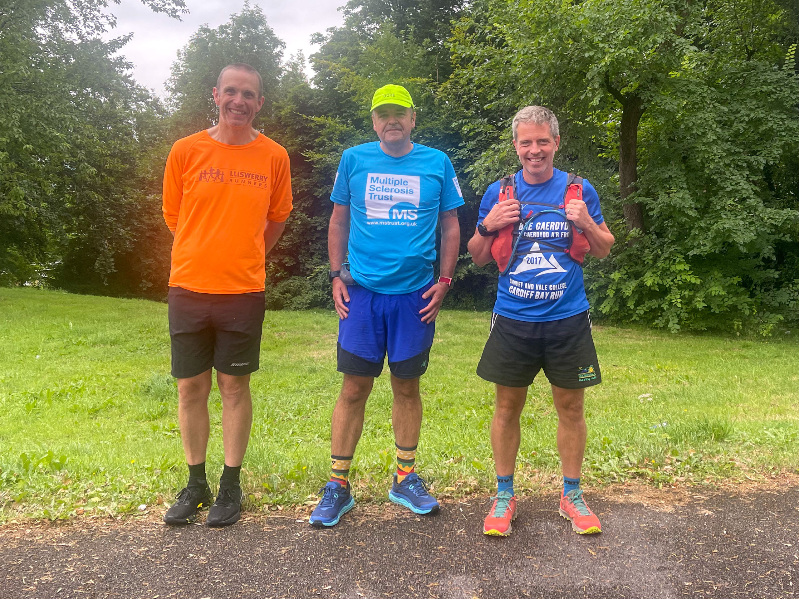
I had two support runners (Chris and Alex) with me for this leg – one runner who had met me on the way to Caerleon and another who had completed an 80 mile 24 hour challenge in May – and the start was a straightforward run along tarmac until we reached the border at Llanhennock where I had plotted a route along what should have been a track. At first we encountered some brambles and nettles but nothing too difficult to get through. Then we hit a wall of ferns which were acting as a gateway to the path of doom.
I’d never experienced a path like it (probably because I would have turned back as soon as I saw the wall of brambles and nettles) but we ploughed on and tried our best to avoid getting stung and scratched but it was futile, there were so many of them. Halfway through I did wonder whether we should head back back and find another route but I we’d come this far so we may as well continue. Eventually we made it out onto a wider, but still tricky path but I felt so guilty taking them along such a difficult route when they had volunteered time on a Saturday to support me.
At the end of the path a car was parked up and whilst I wasn’t expecting to meet anyone I did wonder if it was someone related to the challenge. As it happens it was a a runner from my running club who had tried to catch me earlier in the morning but as the tracker was always a little behind he had missed me. Obviously the painfully slow pace through the path of doom meant that he had been been able to catch me.
After the path of the doom the fields were a welcome relief to run across and then it was back onto tarmac for the rollercoaster Malthouse Lane. I was very much walking every uphill section along the route and on one of the last uphills a car was beeping at us which either meant that they were impatient at us taking up a space on the road or they knew me. Thankfully it was Linda Hoskins, fundraiser extraordinaire who had raised £160 with a raffle. She had travelled down from the valleys to offer some support and even though she was there for just a few minutes it was such a boost.


Rougemont to Ochrwyth
Distance: 8.5 Miles
Terrain: A mix of trail, woodland, country lanes and a hint of canal at Rogerstone.
Notable Features: The scenic Craig y Merchant wood
How the Section Went
Just before reaching Rougemont Alex turned back to Caerleon and Chris continued with me where we’d pick up another Parc Bryn Bach member (Mike and his wife Caroline) for the onward leg to Ochrwyth. It had been pre-arranged to have pizza at this stop so was looking forward to having some although I didn’t feel up to it straight away. I refuelled with Coke, iced coffee and cold custard before heading off. It was a bit of an extended break here and getting going again was tough on the quads.
The start of the leg crosses the canal and follows a path around a house. I had walked along here about 6 weeks prior to the challenge but much like some of the other legs I hadn’t factored in the chance of the vegetation having a bit of a growth spurt. We encountered a mini path of doom but after getting shredded on the previous path of doom I wasn’t in the mood to go through it again so we took a detour along the canal and road which would rejoin the path we would have taken. It was outside the border so didn’t see an issue heading that way.
We followed the road almost all the way to the Castell y Bwlch pub (thankfully we didn’t have to climb that hill). Along the way I had a slice of pepperoni pizza and I like to think that it gave me a bit of an energy boost.
Chris continued up the hill towards the Castell y Bwlch and we turned off the road through some scenic fields and woodland and on the downhill on the road to the back of Bettws I was actually feeling pretty good (that pizza must have worked wonders).
The road to St Peter’s Church, Henllys has quite a menagerie of animals in a farm (pigs, pygmy goats, rheas) and I was hoping that the animals would be there, and they were (although they weren’t close enough for selfies).
We then passed through the scenic Craig y Merchant woodland and on towards Rogerstone where we met Dave again from this morning along with Darren who joined us on the descent down towards the canal where we’d meet Howard and Yvonne who were waiting with Coke, water and sweets. After overheating in the humid weather it was a welcome relief to be able to pour some water over my head to try and cool down.
The next aid station was just a mile or so away and judging by the smell coming from my colostomy bag, it was time for the second change of the day.


Ochrwyth to Michaelston Bridge
Distance: 5.3 Miles
Terrain: Apart from a small country lane section, trail all the way.
Notable Features: The super-steep hill through Ochrwyth and the Rhymney River
How the Section Went
Ochrwyth features the steepest climb on the entire route and there were two options – the tarmac road or the steeper, more technical trail closer to the border. Obviously I chose the trail. I had been given a McDonald’s Double Cheeseburger by a friend (Mark) which had long gone cold so wasn’t easy to eat. I ate some of the burgers but the bread wasn’t going down well so left it.
At the top of the climb we met up with the wife of the runner I had been with since Rougemont and she had warned us of more brambles along the route. Her legs had been cut up by some of the larger ones and I don’t think my legs could have gotten any more cut up so I was wasn’t concerned by a few more. Once through the micro path of doom we were rewarded with some horse selfies! Much like a good rope swing or a cow, I simply can’t resist stopping for a horse selfie.
Dropping down towards Draethen I was stopping and starting occasionally to try and prevent my quads from getting a bashing. Fortunately, the rest of the route was going to be flat following the Rhymney River.


Michaelston Bridge to A48
Distance: 4.2 Miles
Terrain: A bit more road than trail on this section.
Notable Features: The posh houses along Druidstone Road
How the Section Went
Thanks to Mike for extending his run beyond Michaelson Bridge I was able to enjoy the company of another runner for a couple of extra miles. We were rewarded along the way with a badger running in front of us, despite being daylight, and we experienced the oddities of public footpaths by running through the grounds of the Cefn Mably Farm Park.
At Michaelston Bridge I was starting to feel the need for some extra aid stations, not because I couldn’t carry enough supplies with me but more because I just needed to break up the miles before the longer section along the coast between Peterstone Wentloog and Duffryn. Druidstone Road around 2.5 miles was an add on aid station.
I left the aid station and headed up the posh Druidstone Road. This road wasn’t on the original route I plotted but on a recce of the route a couple of months back and two of the paths I wanted had issues – one was tricky to navigate due to mud and another had been intentionally blocked off due to construction of a building. Druidstone Road was the alternative and it remained outside of the border.
Halfway along the road I tuned off-road was greeted with my archnemesis – a corn field! I gave two teenagers a bit of fright as they hiding in the field smoking weed and thinking that I was on the right path I ploughed on through the 6-feet tall corn. I was referring to the OS Map as I was making my way through the field but I wasn’t convinced I should have been there. It looked like the path was drawn in the adjacent field but I was hoping that there may have been a gate at the end which I could have used to get into it. There wasn’t. Back through the corn field I trudged and crossed into the next field.
I was greeted by a huge field of barley with no room at the edge to get around. I had no choice but to walk through it. The dryness of the barley was not going well with my bramble-scratched legs and it felt like walking through fire. I knew that there would be some tougher sections on the course but I never envisaged anything being as tough as walking through those fields. Mentally it was starting to get tough.
I managed to get through the fields only to be greeted with another corn field but thankfully I could use a track to get around it. If that track wasn’t there I think it would have pushed me over the edge.
After the fun fields it was tarmac down to the A48 for another aid station and a decision was made to squeeze in another just a mile or two away. Things were getting tough.

A48 to Peterstone Wentloog
Distance: 2.8 Miles
Terrain: Tarmac all the way!
Notable Features: Things are a lot flatter here (apart from that extra big railway bridge built during electrification).
How the Section Went
I briefly had a moment when I could actually run again for a bit of a distance but that was short lived and I quickly reverted to my run/walk strategy. I added an impromptu station halfway between the A48 and Peterstone Wentloog and used it to change the plaster on my toe which had been uncomfortable for most of the run. I was at around 59 miles so it was only a half marathon to go!

Peterstone Wentloog to Duffryn
Distance: 7.7 Miles
Terrain: Trail all the way!
Notable Features: The Wales Coast Path and the scenic lighthouse.
How the Section Went
This section was always going to be a tough one. I had run it a few weeks before the big day and it was long and uninteresting. I had packed the running poles (aka cheat sticks) just in case I needed them for a tough section and halfway around I had planned to use them the coast path leg. I was a bit tricky using them whilst carrying a water bottle but they helped with both the running and walking.
I had been posting updates on Facebook throughout the day and had mentioned that the section was going to be a tough one so a runner from Lliswerry Runners (Howard) put out a call to a couple he knew that lived in Lighthouse Park which I would be passing. They were kind enough to come out to greet me with a goodie bag of iced coffee and snacks (thanks David and Cara!).


Duffryn to Transporter Bridge
Distance: 3.8 Miles
Terrain: Apart from a tiny piece of trail between Duffryn and Maesglas it’s tarmac all the way home.
Notable Features: The Transporter Bridge of course
How the Section Went
Throughout the entirety of the day I had made sure that I stood up. The phrase ‘beware the chair’ was in my mind and I didn’t want to seize up or get too comfortable that I didn’t want to get back up. By mile 69 I couldn’t resist any longer and perched on the end of the car boot (so not really sitting down). It felt sooo good. It was nice to be able to take the weight off my by now sore feet but I didn’t stay seated for long.
As already mentioned earlier, sweat and colostomy bag glue don’t mix well over a long period of time and it had been 20 miles since the last bag change and I was in need of a fresh bag.
I had my last custard and was ready to set off. There was ‘just a parkrun’ or so left but it was going to be a slog.
The first section is off road and was created so that you didn’t have to walk along the road and at this stage of the challenge I thought that I wouldn’t encounter any more brambles but there were a few more to get through. Thankfully I still had my cheat sticks with me which worked wonders for hacking them down.
With that section finished it was tarmac all the way taking me through Maesglas, Pill and to the west side of the Transporter Bridge. There was a lot of walking but I was still determined to run when I could so it was run for 30 seconds, walk a minute, run for 30 seconds, walk for a minute. Progress wasn’t particularly quick but I just didn’t want to walk the last few miles. I used the cheat sticks at first but they weren’t great on the tarmac and soon realised that it was easier just to carry them when running.
When I reached the Transporter Bridge a friend (Luci) surprised me by waiting for me to pass and offer me some words of encouragement along with taking a photo of me beneath the bridge. The light was fading fast and had just set so finishing before sunset wasn’t possible but if I got there in time I’d be able to get some photos without it being too dark.
I folded up the poles and tried as best as I could to run as much of the remaining mile-and-a-half. I reached Stephenson Street which is a long three quarter mile road and I wanted to make sure I had enough in me to make it all the way to the finish so as I turned the only bend on the street it was a run all the way to the Transporter Bridge. Some friends had turned out to join my parents and welcome me in to the finish and as I grabbed hold of the gate to the bridge I felt like like a finisher on the Pennine Way kissing the pub at the finish line.
I had made it!
Two years in the making, 5 months of training and a plan well executed with the assistance of friends and strangers.
Total Distance: 72.52 Miles
Total Time: 17 hours, 38 minutes and 54 seconds.

Along the way I can remember mentioning twice about the famous Arnold Schwarzenegger motivational talk where he hates a ‘Plan B’. I didn’t want to have a plan B, I wanted to succeed and barring a catastrophe or injury along the way, I was going to make it to the end.
…when you start doubting yourself, that’s very dangerous, because now what you’re basically saying is that if my plan doesn’t work, I have a fallback plan I have a plan B.
If that means that you start thinking about Plan B and every thought that you put into Plan B, you’re taking away now that thought and that energy from plan A.
And it’s very important to understand that we function better if there is no safety net. Because Plan B becomes a safety net, it says that if I fail I have something else there that will protect me, and that’s not good.
Because people perform better when there is no safety net. People perform better in sports and everything else if you don’t have a plan B.
To me, it is very dangerous to have a plan B because you’re cutting yourself off from the chance of really succeeding. One of the main reasons why people want to have a plan B is because they are worried about failing.
Arnold Schwarzenegger
What Did I Learn?
- I underestimated the difficulties of the terrain that I would encounter. I knew that there would be a lot of trail running (perhaps 50%+) but I didn’t factor in how difficult it could get and the effect it would have on my legs. Some of the sections were pretty tough and running through fields and stopping and starting to climb over gates and stiles can sap the energy from your legs.
- Training plans work. I chose a training plan that was realistic but would push me with speed and hill work, long mid-week runs and back-to-back longer runs on the weekend. I stuck to it and it paid off.
- I hydrated well throughout the challenge. In total I had 16 sachets of Tailwind, some Lucozade, iced coffee, lots of Coke and water and I felt hydrated throughout. Carrying a handheld bottle makes it so easy to keep drinking and I was sipping regularly regardless of whether I was thirsty or not. I was also peeing regularly which is a good sign and it was looking a healthy colour.
- I wish I could eat better during a very long run. I had 5 pots of custard, sweets, a few fish ‘n’ chips snacks, Lucho Dillitos, a few slices of pizza, a banana, part of a McDonald’s Double Cheeseburger and the calories from the Tailwind would have been contributing but I wonder if I I would have felt a little better in the latter stages of the challenge if I had eaten more. The problem I find is that I don’t feel like eating.
- Support is key for a challenge like this. In the first half of the challenge running alone was not an issue and I’ve managed long runs of 35 and 44 miles this year where I didn’t encounter anyone. In the second half, running people for quite a few miles was such a huge help and as soon as I was back on my own again things became challenging.
Fuel on the Day
The aim was to stick to Tailwind as much as possible and then top up with other things so this is a list of the things I consumed on the day.
- Tailwind
- Coke
- Lucozade Sport
- Water
- Ambrosia Custard
- Lucho Dillitos Colombian energy blocks
- Dessert Fruit Pastilles
- Haribo
- Burton’s Fish ‘n’ Chips
- Cold pepperoni pizza
- McDonald’s Double Cheeseburger
- Starbucks mini waffles
- Saltstick tablets
Animals Spotted
- Horses
- Cows
- Donkeys
- Vietnamese Pot Bellied Pig
- Alpacas
- Rheas (or something similar)
- Pygmy goats
- Rabbits
- A badger
- A buzzard
Who’s Next?
The bar has been set, who wants to try and beat the fastest known time for the Tour de Newport?


No Comments